Something very much like this has, over the eons, repeatedly occurred in what is currently the Wadden Sea area. Wadden Sea is the Anglicization of the Danish 'Vadehavet' which means mud-flat sea. In southwestern Jutland (the part of Denmark on mainland Europe), down through northwestern Germany and west across the northern Netherlands, simple daily tides still move the shoreline in and out by some miles. In between are extensive mudflats. As was done in Holland, the people of southwest Denmark gradually, over centuries, drained much of this tidal area with dikes, building walls over which the tide cannot climb (except during large storm floods, which throughout the middle ages would occasionally overcome the dikes and drown thousands of people). Despite the dikes, and the normally small tides of ~1.5m, the inter-tidal zone is many km wide in this area.
Iris and I spent a day on Mandø, an island in the Wadden Sea. The Danes long ago surrounded the island, which is only a few kilometers across, with dikes, and most of the interior is grazing land for cows and sheep. There is also a village of about 50 people, and an environmental education center/hotel, where we stayed. Outside the dikes, which are basically just 3-5m high slope-sides earthen walls grazed by sheep, there are wetlands surrounded by huge areas which daily alternate between being land and sea. At low tide one can drive to Mandø, or go for long walks on the mud-flats. At high tide it is water on every side for miles.
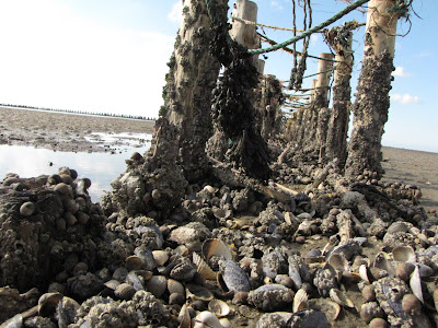
100m or so outside the dikes most of Mandø's shoreline (if it can be called that when it is often miles from the water) is ringed by fences that are about knee high. Each fence is made of two rows of sticks driven vertically into the mud, with thinner sticks, bits of brush and whatever else tied into bundles and wedged into the space between the two lines. Iris and I were mystified as to what function this short fence could perform, other than giving homes to billions of barnacles and perches to the preening shorebirds. It turns out these funny little fences, over generations, wrest land from the sea. At high tide water with sand and mud in it pours through, over and around the fence. As the tide recedes, much of its sediment gets caught in the bundled brush, like krill in the baleen of a whale. The area within the fence eventually fills with soil up to the top of the fence, and another fence is built further out. Repeat for 1000 years and add sheep.
Danish policy, now that they finally have the technology to seize the entire mud flats in years rather than centuries, is to let the boundary stand where it is. Let the shellfish, the shorebirds, the mud worms and the crabs keep what they have, and let the farmers keep their hard-won dry land. This summer Nationalpark Vadehavet became the largest national park in Demark. (Germany has also made large portions of its piece of the Wadden Sea into national parks.) It is bizarre, mysterious and wonderful to visit, and a glorious piece of wildness on the edge of all too tamed northern Europe. Global climate change may well doom the Wadden Sea to return to just being a flat seabed, so I suggest a visit sooner rather than later.
Here are a few photos:
Iris on the mud flats

Disintegrating coastal fence encrusted by shellfish

Oystercatchers like this one are extremely numerous in the Wadden Sea. Their long stout bills are perfect for wrestling invertebrates out of the mud.


No comments:
Post a Comment